Jeff Zimmerman shares the story of one day out in the field photographing wildfires
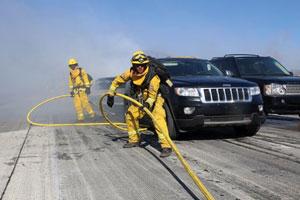
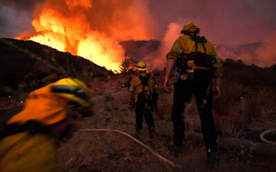
There was a fast-moving wildfire in the Cajon Pass along Interstate 15 near Highway 138 in San Bernardino County. (Photos by author.)
JEFF ZIMMERMAN | From the February 2016 Issue of FireRescue Magazine
On Friday, July 17, 2015, I was on call as an emergency photographer in Los Angeles (CA) when I received a text message that there was a fast-moving wildfire in the Cajon Pass along Interstate 15 near Highway 138 in San Bernardino County. The Cajon Pass is notorious for fast-moving vegetation fires because the freeway is lined with grass and brush; there is also a major railroad spur going through the steep mountainous area, and thousands of travelers use the steep mountain pass every day. Fire is commonplace in the area, so I was not too concerned about the initial report even though temperatures had been in the 90s and California is in severe drought.
Approximately ten minutes later, I received a text message that the air attack officer was reporting that the fire had grown to more than 50 acres and that that the fire was going to impact the southbound side of the freeway as well as the northbound side. Knowing that the initial report was that the fire started on the northbound side of the freeway and that it was already going to jump the southbound side, I knew this would drastically impact traffic, so I left my staging area in Pacoima and started to head up Interstate 5 to freeway 14. Traffic is terrible on a Friday afternoon, so I knew it would take a bit longer than usual to hit Pearblossom Highway to go east to freeway 138 just past the Mormon Rocks forestry station.
Trapped By Fire
Once I made it to Little Rock, I could see a clearly defined column of smoke starting to form an ice cap on it. Judging by the base of the column, I would have estimated the fire at approximately 200 to 300 acres or more, which is a very explosive rate of spread in 45 minutes. There was some instability in the air that was allowing the column of smoke to form that distinct cauliflower anvil-shaped head associated with large-scale wildfires. I received yet another text message that the fire had jumped the freeway and that people were now trapped in their vehicles by fire and having difficulty escaping the flames.
The reports kept coming in of injuries and firefighters trying to evacuate people from a bottleneck of burning vehicles. I heard a radio report asking for medevac helicopters to land on the freeway; firefighters were starting to treat and triage injured bystanders, and there was a need to form a medical group in addition to fighting the fire. Mind you, this is a busy Friday afternoon, traffic is jammed on the freeway, there are injuries, and 15 or more vehicles were burning in what was reported as a vegetation fire. Now completely out of control, the wildfire became a major incident for the United States Forest Service, the San Bernardino County Fire Department, and Cal Fire. The radio continued to crackle in reports of injuries and requests for more resources, aircraft, and crews.
The Fire’s Path
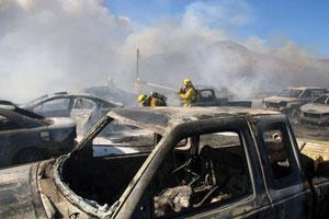
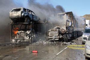
Cars were blistered or totally consumed in several lanes of traffic.
By the time I arrived, I estimated the fire to be approximately 500 acres. Approximately 15 vehicles were burning, two large semi-trucks exploded into flames as I approached, a fiberglass boat on a trailer was actively on fire, and people were still moving north on foot up the steep freeway in strong winds with blowing embers. A huge column of smoke was visible in the clear blue sky for miles around. A strong south wind was rapidly pushing the fire up the canyon and over the ridges to the northeast toward the high desert floor and homes in Oak Hills. I knew the fire would soon be bumping into structures, mostly in an area of single-family dwellings surrounded by desert scrub and accessible by dirt roads.
As I maneuvered on foot up the freeway, I felt as if I was a kid in a fast-paced game of dodgeball, but instead of dodging a ball, I was outmaneuvering burning cars, blowing debris, and racing acrid black smoke-I knew this was no childhood game. I hustled up the southbound lanes of traffic, up a steep grade, and found all three agencies trying to put out burning vehicles. Cars had stopped suddenly on the freeway in blinding smoke as the fire overtook their position, causing a traffic jam. This near deadly bottleneck of vehicles blocked other drivers from escaping the flames in their cars, so they had to abandon them and leave on foot, regardless of how they were dressed and what they had in their hands. There was no time for clear rational decision making; it was a time for flight on foot in an effort to find safety on the freeway in the middle of a firestorm.
Of course, most civilians have no idea what a safety zone looks like or how fire really behaves in the wildland, traveling up shoots and chimneys at explosive rates of spread. A wide spot in the road might save your life, and just seconds may determine who lives, who is injured, and who dies. The look of panic and concern on the civilians was startling. But I knew I had to keep moving, keep shooting, keep documenting; there was no time for interviews of trapped bystanders or firefighters, I told myself to just keep moving. There will be time for interviews later. Of course, there were reports of people who drove through the flame front and escaped unharmed with children in their car; others were not so lucky.
I recalled the Caldecott Tunnel fire in the Oakland Hills and my personal experience on the Sayer fire as a Santa Ana wind-driven fire swept over 500 mobile homes and vehicles in Sylmar, California, destroying everything in its path. As with this fire, the smoke was extremely irritating to the nose and eyes as it lay over the freeway in a thick blanket.
Fighting the Fire
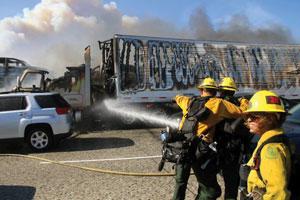
Crews attack burning vehicles in an attempt to stop the fire spread.
The vegetation along the freeway was still actively burning, with guard rails, trash, and rubber mats pumping out choking smoke. Cars were blistered or totally consumed in several lanes of traffic. As I walked toward the freeway, a large semi-truck erupted violently into a ball of flame. Helicopters dropped water onto the wreckage of burnt hulls of vehicles to try and stop the flames from consuming other vehicles. Fixed-wing air tankers dropped fire retardant onto the flanks of the fire as the head pushed over the ridge top. It looked like something out of an apocalyptic event, definitely not your routine brush fire.
Crews from the Forest Service were used to attack burning vehicles. It is not their usual modus operandi to fight vehicle fires while the wildland is burning, but this was no ordinary fire. There was difficult accessing the fire with county and state equipment, so it was everyone for themselves for a bit-what I call cowboy-up, boots and saddles, hit the ground running.
These are the fires where well-disciplined, well-trained fire officers and aggressive firefighters make all the difference. Fight fire intelligently where you find it, hold and flank, protect exposures, and save lives and real property. Don’t waste any time protecting total losses, and always keep moving regardless of how tired you are. This is the meat and potatoes of firefighting: hard, aggressive firefighting; dirty grunt work; ground pounders doing what they do best. The theater of battle has been set in motion. Television crews are carrying the battle live from aerial TV cameras and citizens are recording the chaos on cellphones and posting it on social media in real time. No classroom training can prepare you for this type of event, so you need to rely on your years of experience and safety standards to make safe and effective attacks with calculated risk to firefighters.
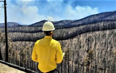
By the time I made it back to my truck, I estimated the fire to be approximately 3,000 acres and growing, so I went to the northeast edge of the fire. There, on Rattlesnake Road, I found a home well involved with fire and crews working frantically to support helicopter operations. I determined that probably a dozen or so homes or outbuildings would be lost, and I think the finally tally would be pretty close to that. I knew that rain and thunderstorms were predicted for the following day, so the brunt of the fire would be over in the first five hours or so.
Fires in the desert seem to slow considerably after the sun goes down, and this fire would be no different. The north fire with its flames being beaten back by weary firefighters would slowly be contained in a day or two, being held in check at an estimated 4,200 acres by thunderstorms.
Another Opponent
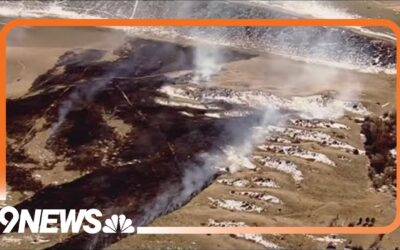
After sunset, it is difficult at best to photograph images unless homes are still burning, but I had been at work for 12 hours already so I started home. At 9:33 p.m., my text alert went off again for a new fire high up in the Angeles National Forest. It would take me an hour to make it to the new start at Big Pines Highway and Angeles Crest. Weary and dirty, I reluctantly left for the new fire. Aircraft from Los Angeles County reported a fire approximately three to five acres in size near a camp with a structure threat and ordered a second-alarm assignment.
I know Table Mountain well from hiking in the area in the off season. While driving down Pearblossom Highway for the second time in a day, I could clearly see the flame front sloping over the ridge on Table Mountain in the dry timber. The proximity of this fire could easily threaten the town of Wrightwood in San Bernardino County if conditions were just right. The fire originated on the border of Los Angeles County and Forest Service jurisdictions, so joint command was established. Forest Service crews had to be recalled back to duty as the ridge top winds in front of the thunderstorms pushed the fire.
No classroom training can prepare you for this type of event, so you need to rely on your years of experience and safety standards.
I always told my firefighters when there is one fire in zone there will be multiple fires in zone, referring to the south zone operational area of Region 5 in California. This day would be no different because conditions were just right for large-scale fires. A new start high in the timber country with an entire town standing in its path spells trouble with a capital T. I am no ordinary photographer, because as a retired fire captain I am used to very long shifts and staying awake when others have long gone home.
I told myself, you can’t take pictures if you are sleeping, so I pushed up Table Mountain on foot in very strong winds to try and capture some images. By midnight, I estimated the fire to be approximately 150 acres and by morning 200 acres. The thunderstorms arrived with wetting rains and quickly doused the fire, halting its forward progress.
Heavy rain was predicted, so it was no time to get trapped in a mudslide in the mountains. I have made this mistake before; I guess I learned by doing.
End of a Shift
On my way home, now being awake for a full 26 hours, I stopped to photograph some of the lightning in the area before driving an hour and a half. Of course, it was finally time to stop for a hot cup of coffee and some breakfast.
During 26 hours on the line, 4,400 acres were consumed, several structures burned to the ground, at least 15 vehicles had been incinerated, and hundreds of people narrowly escaped the flames. Then monsoonal moisture from tropical storm Delores had pushed in and brought copious amounts of rain to the area. Now the opposite end of the spectrum fast approached, with too much rain falling too quickly, potentially leading to rockslides and mudslides. By nightfall, one home in Frazier Park had been inundated with mud and a hundred or so people were stranded at an evacuation shelter.
Lessons learned: Have a fire extinguisher and supplies in the car, including drinking water, blankets, simple snacks, extra shoes, medications, jumper cables, flashlight, and maps. Always be prepared for a disaster-you never know when it will strike.
Jeff Zimmerman is semiretired from the fire service. He served as a fire captain in the San Luis Obispo (CA) Fire Department and also worked for the Los Angeles (CA) Fire Department, the United States Forest Service, and several private ambulance companies.