Columbia River Gorge has seen big slides in the past
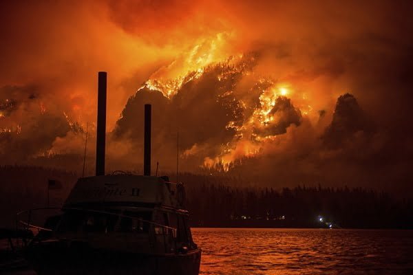
This photo provided by KATU-TV shows the Eagle Creek wildfire as seen from Stevenson Wash., across the Columbia River, burning in the Columbia River Gorge above Cascade Locks, Ore., on Monday Sept. 4, 2017. Wildfire smoke is especially dangerous to people with chronic heart and lung problems, said Julie Fox, an environmental epidemiologist with the Washington State Department of Health. The smoke is a combination of several toxins, and its tiny particles can be inhaled deeply into the lungs, she said. (Tristan Fortsch/KATU-TV via AP)
By ANNA KING, Northwest News Network
Geologists for the state of Oregon are warning of the risk of major landslides in parts of the Columbia River Gorge that were hit by wildfires this year.
A new report released Thursday focuses on areas of the Gorge that are highly susceptible to landslides — which also happen to overlap with some of the areas hit by this year’s wildfires.
“When an area like this has a wildfire, it actually increases the susceptibility,” said Bill Burns, an engineering geologist with the Oregon Department of Geology and Mineral Industries. He is one of Oregon’s top experts on landslides and the author of the new report.
What Causes Landslides In The Gorge?
Typically, landslides happen when soil becomes unstable after heavy rain or rapid snowmelt. Earthquakes may also play a part.
When logging or fire strips the topography of trees, shrubs and grasses, water can infiltrate the ground and make it more prone to sliding. Forest fires can also scorch the soil and cause more runoff.
The Gorge has seen big slides in the recent past.
“In 1996 and ’97 we had several large storms that caused landslides in the Columbia River Gorge,” Burns said. “And these landslides came down the Gorge walls, engulfed the communities and Interstate I-84.”
Mapping The Risk
Burns said his study helped create new maps of where landslides have occurred in the past. He said these past slides greatly determine where landslides will occur in the future.
For his study, Burns compiled information from historic records down to the county level, along with old photos. He also looked at landslides through LIDAR images — high definition aerial data that can reveal the contours of past landslides.
So far, in the area that he studied in eastern Multnomah County, Burns has found evidence of 286 landslides — recent, historic and prehistoric. Some have been catastrophic, with mud traveling a mile. By contrast, the 2014 Oso landslide in Washington had a runout of about three-quarters of a mile.
The Historic Risk
The Columbia River Gorge was formed largely by the Columbia River basalt flows and scoured out by the Missoula Floods. Those were massive flooding events that pulsed huge volumes of water from a breached ice dam in Montana down the gorge to the ocean. That action scoured out a canyon whose nearly vertical slopes constantly slide.
The Gorge is home to thousands of people and is a popular destination for tourists, hikers and recreationalists. Interstate 84, Oregon’s major east-west corridor for traffic, also runs right along the river’s edge.
“If this were somewhere in the middle of nowhere we wouldn’t be as concerned,” Burns said. “This is a really high traffic area and we’re really concerned.”
The Washington Side
The Washington state side of the Gorge has experienced huge landslides as well. For example, the Bonneville Landslide, also called the Bridge of the Gods Landslide, reached all the way across the Columbia River before Lewis and Clark paddled down the Columbia.
Currently, Washington’s Highway 14 is closed to commercial truck traffic, as the highway is absorbing all other traffic from the closed portions of Oregon’s I-84.
Washington State Department of Transportation Safety and Emergency Operations Manager John Himmel said his state is trying hard to keep culverts and roadsides open to accept any debris that comes down.
“Highway 14 is already a landslide-prone area,” Himmel said. “So yes, we are watching that.”
Usually, more severe damage happens when culverts are clogged and water and debris flow over- or under-cut the roadway. But Himmel said slides often occur on private property adjacent to the state’s right-of-way. So there isn’t a lot the state can do before slides occur.
Present Danger
Burns said the area will be at heightened risk for landslides this fall and winter, but the hazard could continue for several years. He said people can do several things to lessen their risk of getting involved with high-velocity dirt and mud.
“When the National Weather Service is predicting periods of intense rain, be extra cautious and maybe avoid the area,” Burns said. “If you have to travel through there, do it at daytime when you can react quicker and better.”
It can rain incredibly hard in the Gorge. But even with the few recent sprinkles, Burns said he’s “already concerned.”
Landslides are quick. They can travel tens-of-miles an hour, so it’s easy to get caught.
Burns said it may take years for the Gorge to settle down from the effects of these fires.
“Especially their first winter and winters to come,” he said. “We’re going to have to see how this area is going to react.”
All contents © copyright 2017 Associated Press. All rights reserved.